Maria Island and Long Point Convict Stations
Tasmania is blessed with some pretty spectacular places. One of the best of these is Maria Island, off the State’s east coast. Today run by Parks and Wildlife, it is an attractive destination for day visitors or overnighters, the island happily unblighted by intrusive modern development. While its scenery is something to write home about, we’ve been particularly engrossed by the island’s fascinating history, the remnants of which litter the island in the most photogenic of ways.
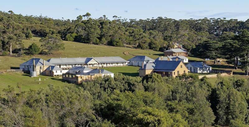
In 2021 we received an Australian Heritage Grant for our project Recovering Darlington Probation Station’s Hidden Convict Landscapes. Maria Island had been lucky enough to be home to not one, not two, but three convict stations during the 1820-1840s. The first of these was the Maria Island penal station (1825-1832), which had a new lease on life between 1842-1852 as the Darlington probation station. Long Point, situated halfway down the island, was the site of an agriculturally-focussed station between 1845-1848.
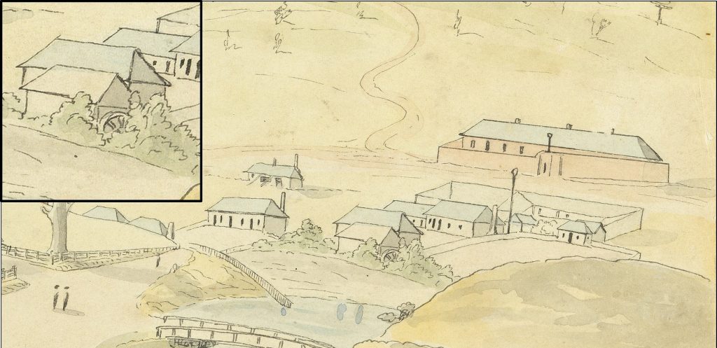
In collaboration with Parks and Wildlife, we undertook a series of LiDAR-based archaeological surveys of the landscapes around the stations, using all the skills we had learnt during the Convict Landscapes project. This revealed a landscape dotted with sites of convict industry: trackways, brickpits, lime kilns, agricultural fields, even a hop kiln. It was all the stuff we would expect from a convict labour hinterland. At Long Point we recorded a vast agricultural landscape, the rig-and-furrow and stone field clearance mounds marking the location of hundreds of acres of wheat and root crops.
We were particularly on the hunt for evidence of the first penal period at Darlington. Only two buildings, the prisoners’ barracks and the commissariat store, remain from that period. The station had been the scene for a complex cloth-making manufactory, incorporating water-powered machinery and an accompanying mill race. Constructed of timber, none of these buildings survived the probation period. We used geophysical survey – Ground Penetrating Radar and Resistivity Meter – across the site. As usual, this type of survey raised more questions than it definitively answered, though we did pinpoint the location of the mill race and could then estimate the position of associated structures.
The post-convict impacts were also of interest. At Darlington the place had been taken over by A.G.D. Bernacchi in the 1880s and 1890s, who converted convict-period buildings into accommodation and offices, as well as added new structures. He planted tens of thousands of vines (which soon failed) and worked the convict-period limestone deposits. These were then worked on a much larger scale during the 1920s and 1930s, with the limestone quarried and converted into cement.
As well as the usual large, impenetrable reports, we were keen to produce outcomes that people actually wanted to look at. The first of these was the map below. Another, for the more learned, was the book Maria Island: History and Landscapes 1825-1930
{link to bookseller page (https://www.navarine.net/product/maria-island-history/51)}
Project Personnel
Martin Gibbs (UNE)
Richard Tuffin (UNE)
Mike Nash (Parks and Wildlife)
Fieldwork volunteers: Hannah Waterhouse, Karen Welsh, David Roe
Tasmanian Parks and Wildlife staff: Katherine Hitchcock (Officer in Charge), Martin Fieldhouse, Andrew Hitchcock (Field Officer), Madalyn Riley (Ranger), Andrew Ryan (Ranger), Geoff Swan (Field Officer)
Project URL: https://convictlandscapes.com.au/mariaisland/
Key Personnel:
Dr Richard Tuffin
Professor Martin Gibbs
Related Publications
Sorry, we couldn't find any related publications.